Modern roads and developments bear more resemblance to ancient urban centers than we often think – which is certainly true of the sprawling settlement of Teotihuacan, once located 40 kilometers northeast of Mexico City.
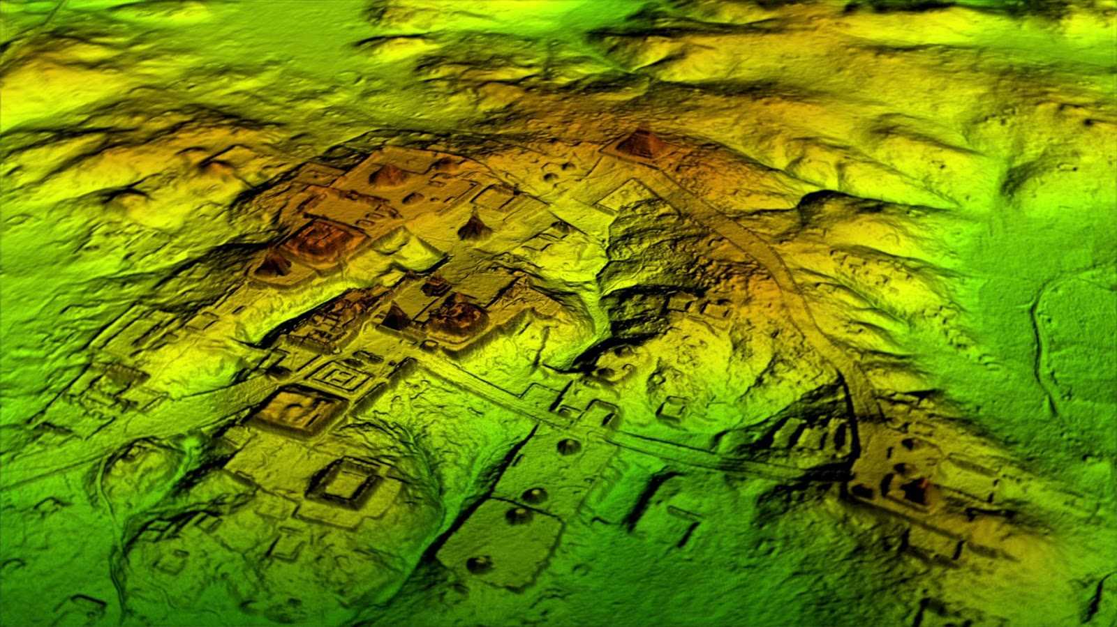
Researchers using LIDAR (“light” and “radar”) scans found that the contours of Teotihuacan – much of which is now built up and hidden from view – are still reflected in roads and structures erected on the same site today, some 1,500 years later.
The same study has also shed light on some of the amazing engineering done by the people of Teotihuacan: changing the direction of rivers to match astronomical points, moving vast amounts of soil and bedrock to form their city.
“We don’t live in the past, but we live with the legacy of past actions,” says anthropologist and archaeologist Nawa Sugiyama of the University of California, Riverside.
“In a monumental city like Teotihuacan, the effects of those actions are still fresh on the landscape.”
Between 100 B.C. and 550 A.D., Teotihuacan was one of the largest cities of the ancient world, covering about 21 square kilometers or 8 square miles. It consisted of many pyramids, plazas, and other commercial and residential buildings.
Some of Teotihuacan’s amazing structures have survived to this day, but many have been lost, and this is where LIDAR aerial mapping technology comes in. It uses reflected laser light to measure structures and materials underground.
Here, researchers used a combination of LIDAR, walking surveys and previously collected mapping data to make a comparison between ancient Teotihuacan and the modern Teotihuacan Valley, now a UNESCO World Heritage Site.
They found that 65 percent of urban areas in the region contained properties or sites that were aligned orthogonally within 3 degrees of 15 degrees east of astronomical north – the same alignment in which Teotihuacan was carefully constructed. Meanwhile, modern stone fences were built along the same lines as the ancient walls, now underground.
The ancient Teotihuacans also invested heavily in altering river channels and building canals: Researchers have found that some 16.9 kilometers (10.5 miles) of existing waterways originate in the landscape of early Classical Teotihuacan.
“The unique ecological, cultural and scientific trajectories of the Teotihuacan Valley support a multiscale definition of humans as geomorphic agents,” the researchers write in their published paper.
The study estimates that some 372,056 square meters (4,004,777 square feet) of artificial soil have been deposited in the region over 300 years. A total of 298 sites and 5,795 artificial terraces have been discovered that were previously unrecorded, as well as more than 200 sites that once existed but were wiped out by mining operations.
Archaeologists continue to uncover new secrets about Teotihuacan and its history-we have previously seen researchers use the latest technology to uncover hidden tunnels and ritual offerings in the ancient site.
With this latest research, we know that the innovations and choices made more than a thousand years ago continue to influence civilization.” Next, the team wants to expand its LIDAR mapping to cover a larger area in three dimensions and over a longer period of time.
“We can’t fight modern urbanization,” Sugiyama says. “The LIDAR map provides a snapshot of these ancient sites being destroyed at an alarming rate that would otherwise go unnoticed. This is one of many ways to preserve our historic landscape.”
The study was published in the journal PLOS One.